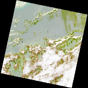
LC09_L2SP_193057_20221201_20221203_02_T2_SR_stac
dataset of product ls9_sr
Indexed by odc_writer
,
created
Region
193057
for
1st December 2022
Fields 🔗
cloud_cover
57.72
collection_category
T2
creation_time
2022-12-01 10:16:30
crs_raw
•
data_coverage
•
dataset_version
•
eo_gsd
•
eo_sun_azimuth
139.705
eo_sun_elevation
55.208
format
GeoTIFF
id
534754e1-263f-5cd8-96cc-b58eff375503
instrument
OLI_TIRS
label
•
lat
3.291 to 5.378
lon
-1.308 to 0.705
platform
LANDSAT_9
product_family
•
region
•
region_code
193057
rmse
nan
rmse_x
nan
rmse_y
nan
sat_orbit_state
•
sat_relative_orbit
•
time
2022-12-01 10:16:30 to 2022-12-01 10:16:30
Related Datasets 🔗
LC09_L2SP_193057_20221201_20221203_02_T2_SR_stac